The Waikato River Trails - 'the Taniwha' track - Taupo Accommodation Booking request
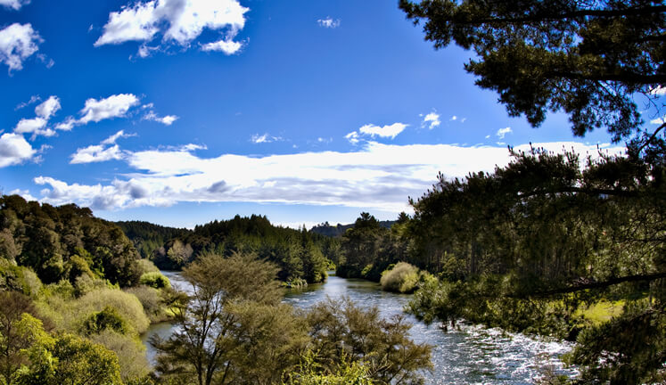
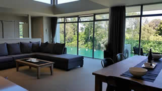
Riverside Apartment in Taupo is the ideal base when biking or walking the Waikato River Trails
Located just 40km from the Atiamuri end of the Waikato River Trails, Riverside Apartment is an ideal holiday home to rent while cycling, walking (or even running!) the WRT. Easy road access can be gained to each start point and mid-points along the trail at Arapuni, Waipapa, Mangakino and Whakamaru.
Both apartments at Riverside have a double garage so it's easy to securely store your mountain bikes and car below the apartment. Book the best accommodation - you won't regret the drive to get back on the trail as our river views are stunning and the quality of the accommodation is (in our view) significantly better than what is available on the trail itself. For the best rates, guaranteed, book Waikato River Trails accommodation directly with Riverside Apartment.
Map of the Waikato River Trails
This guide to the WRT describes the trails from a north-to-south direction. The 103km run, as detailed further down the page is in the opposite direction, starting at the Atiamuri / Pohaturoa dome trail head.
1. Karapiro Section - Pokaiwhenua Bridge to Arapuni Village
Grade 2-3 (Easy to Intermediate). Distance - 11.5km.
When traversing the Waikato River Trail from north-to-south, the trail starts at the Pokaiwhenua Bridge carpark. This section is gently undulating and will appeal to most riders, even those of low or moderate levels of fitness. Riders or hikers will pass through the Little Waipa Reserve where toilets can be found and across the Huihuitaha wetland boardwalk finishing at the Arapuni Swingbridge, some 400m from the Arapuni village.
2. Arapuni Section - Arapuni to Waipapa Dam
Grade 4 (Advanced). Distance - 36.0km.
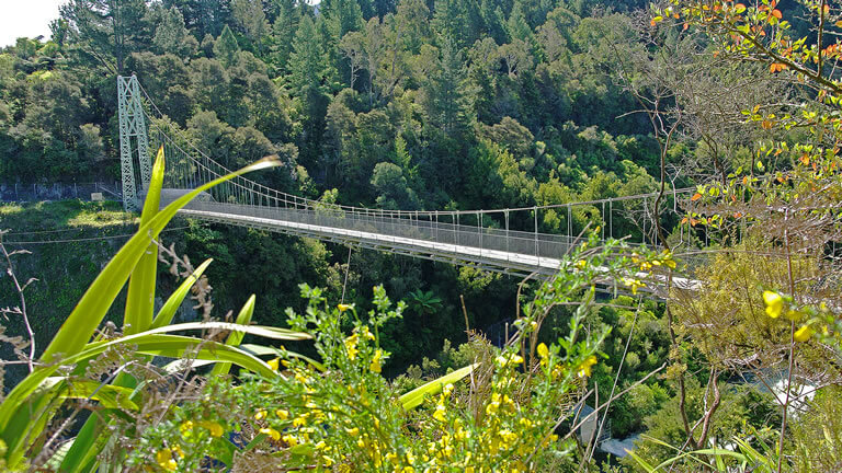
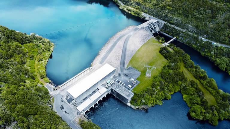
From north-to-south this section of the Waikato River Trail starts at Arapuni and passes the impressive Arapuni Dam. Running alongside the river some great views are enjoyed until Jones Landing (where toilets are available) at which point the trail then follows Lake Arapuni Road to Jim Barnett's Reserve (more toilets and parking available). The road takes you to the intersection with Waotu South Road before the trail rejoins the river. Crossing the Mangarewa Bridge which is suspended some 42m above the stream below brings you to the final point of interest, the Tumai steps which have wooden tracks built in so you can push your bike up (or down) them.
3. Waipapa Section - Waipapa Dam to Mangakino
Grade 4 (Advanced). Distance - 19.0km.
Custom built, forestry and native bush trails connect this 19km section with a short 3.5km final stretch along the road in the direction of Mangakino. Obstacles and steep climbs give plenty of challenge in this demanding section of the 'Taniwha'.
4. Maraetai Section - Mangakino to Whakamaru Dam
Grade 3 (Intermediate). Distance - 12.1km.
Food and drink stops at the 'Bus Stop' and 'Hui Hut' cafes in Mangakino and the Dam Cafe in Whakamaru mark the start and end points of this moderately technical section with the 70m long Mangakino Stream suspension bridge in the middle.
5. Whakamaru Section - Whakamaru Dam to Atiamuri
Grade 3 (Intermediate). Distance - 23.5km.
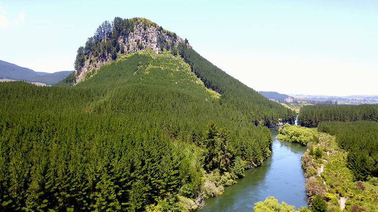
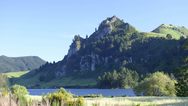
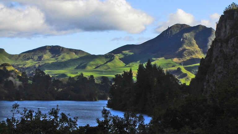
From north-to-south (which in fact is more like west-to-east in this section) beginning at the Whakamaru Dam the Whakamaru Section is one of the most scenic on the WRT, as the river is almost always in sight. The Lake Whakamaru Reserve with its pines (recently felled, unfortunately) and the stunning Ongaroto Bluffs provide some of the highlights on this moderately technical section. Finishing across the lake is the magnificent Pohuturoa Rock.
Notes and more information
Cellphone coverage is only in place for about 40% of the entire trail. Ensure that the blue bi-directional markers are followed as it is possible to get lost when on the trail! Many of these markers have GPS positions, likely cellphone signal quality and a unique number - remember that in NZ the emergency services phone number is 111.
For updates, more information and trail maps please visit the Waikato River Trails website.
Running the Waikato River Trails
An ultramarathon of epic proportions and stunning beauty by Greg Caie
Why run the length of the Waikato River Trails?
I have a long-lasting love and deep affinity for the Waikato River. At its source it flows beneath the windows of Riverside Apartment at the Watermark Villas complex, winds its way north through the beautiful Waikato region, my spiritual home and flows into the Tasman sea on the rugged west coast of the North Island - where I spent a lot of my time growing up. I also have a passion for running and more recently, running the trails - for quite some distance.
The idea for running the entire length of the Waikato River Trail (or 'Taniwha') grew like an invasive plant in my mind. The longer it was there the harder it was to ignore, so the runs I went on evilly became longer, harder and hillier with the goal of completing 'the Taniwha' in one hit. By the summer of 2020 I was ready to attempt it - well, as ready as I ever was going to be. I had run the 50km from Atiamuri to Whakamaru (and back) on a hot and sunny day and felt woefully fatigued at the end of that, but it taught me a valuable lesson. Go slow - and choose a relatively cold and breezy day to attempt the full distance.
Preparation
In addition to the obvious building of distance and stamina, I felt it was important to be self-supporting during my run of the Taniwha. I also wanted to complete the run with no waste or rubbish left behind, not a scrap. To achieve this I chose to place drop-bags at Arapuni, Waipapa and Whakamaru. I will be forever grateful to Linda and my two children for meeting me at Waipapa (around the half-way mark) to encourage me onwards. My artistic daughter decorated the drop-bags with enthusiastic messages and her sage words of advice - "walk the hill" - were gold. The bags were dropped in a north-to-south fashion as I drove south and close to the road so they were easy to position. With a Camelbak full of water and stomach full of butterflies it was time to tame the Taniwha, starting at the Atiamuri end.
Taming the Taniwha
Leaving the car in the carpark just off State Highway 1 at the Atiamuri Bridge Carpark I started my watch (my choice is a Garmin Fenix 3 as it has great battery life) after ensuring the GPS position had been acquired. The first leg of the Waikato River Trail is one of my favourites. The culturally significant shape of Pohaturoa, a 400,000 year-old lava dome emerges from the fading darkness as the sun makes its way towards the horizon on the morning of January 5, 2020. I've chosen this day based on the forecast, a maximum of 20 degrees Celesius (68 degrees F) and gusty south-westerlies. Cloud is anticipated during the morning but a late change in the forecast has it thought to burn off in the afternoon, not ideal, but after a lot of planning it has to be done today. 14 hours of daylight - it should be enough although I have a head-lamp stowed in my Arapuni drop-bag. If I need it I will be in a world of hurt.
The trail mostly follows the serene flow of the river and there are very few road sections. It is gently unulating, mostly smooth and unrutted, allowing the runner time to take in the scenery and magic of the river. The river is wide and slow. The trail is sheltered by the trees for the most part but approaching Lake Whakamaru the wind howls through the valley creating white caps on the river. I bypass the steps (which apparently offer a brilliant view) to preserve valuable energy and continue on the 'cyclists' route which follows the road for a few hundred metres. Freedom campers at Dunham's Reserve and the Whakamaru Reserve are my only human sightings on the first leg - apart from a few motorists on State Highway 30 who are travelling at significantly greater speed than I. I am forcing myself to slow down to a pace of 6 min/km as I'm not even sure that I will be able to complete the run and know if I hit it too fast (as I have in the past) then I will certainly fail.
So far so good
Still on the move I phone Linda as I cross the Whakamaru Dam to let her know that I will meet her and the kids at Waipapa around half an hour earlier than planned due to an earlier start at 5:30am when there was sufficient light. I pick up the drop-bag at Whakamaru and replenish my water reservoir. Stowing the bag for pickup the next day and continuing on, the first 25 km have gone well and I'm feeling pretty good. The river plunges far below the trail after the Whakamaru dam and the eurphoria of what I am doing is surging through me. I know the pain is coming so I force myself to keep the pace slower than I would normally run and continue with the SIS gels and hydration intake up. The trail is windy and undulating and gradually drops to meet the level of the river by the Mangakino swingbridge. I find it hard to keep a pace over the swingbridge that doesn't create an odd harmonic of the bridge bouncing up to meet my stride. At the 32km mark I wonder if I am becoming more focused on completing the run than enjoying the views because this leg-damaging bouncing bridge seems more important to sort out than taking in the vista. I meet a cyclist coming the other way at the bridge, ironically the only other person on the trail so far and it happens at the bottleneck one-way of the Mangakino bridge!
As the summer playground of Lake Maraetai comes into view it is not far to go to the small township of Mangakino. For those not familiar with the Waikato River, these 'lakes' are little more than the widening of the river, controlled by the hydro-electric dams found along the way. Disappointingly the trail joins Waipapa Road for a gentle but steady incline for a few kilometres, the first on-road section - from the village of Mangakino the blue signs marking the trail along the road are few and far between so it is several hundred metres before the reasurrance is gained that I am going the right way.
You are going the right way... but not for long
Past historic dam construction sites the path hugs the river as Waipapa Road splits away to the west. It is along the forestry road tracks of this section that I miss a vital turn off sign with about 7km to go to the Waipapa Dam. As the track at this point is so wide and obvious I convince myself I'm on the trail, but I'm nervous that I have missed a turn off though continue in the belief that the markers (as they were was out of Mangakino) might be few and far between. The compass on my watch confirms I'm going the wrong way, and in doing so I add a total of 4km to the trip - I am cursing my lack of observational skills. The dilemma that this has caused is significant in that I have a rendezvous time at Waipapa (which is now going to be sorely tested) and that is assuming I can regain the track. Ducking under a fallen tree (maybe that should have been a sign) I find the marker that is bent over at a 45 degree angle which I missed on the way past. This is a good thing because a return to Mangakino would have been the end of the attempt. Running late now I pick up the pace a little and rue the extra distance (and significant hill climb) that I've just added to the total distance.
59km have elapsed as I arrive at the Waipapa Dam picnic and parking area. Fortunately I am only a few minutes late and my family seems excited to see me there. My wife wryly (and correctly) observes that I am looking a little fatigued. I casually relay the story of how I added another 4km to the journey and restock my Camelbak. Even though I am diligently taking electrolytes in addition to water and energy gels (my choice is the less sickly SIS gels) the craving for potato chips is there as my body is telling me to keep the salt levels up. Given the choice to give up there and attempt it another day I decline and after the few minutes of rest I hobble off again. My legs have stiffened up and the monster-sized kerbs of the road as I cross the Waipapa Dam are a challenge to mount.
The Arapuni section of the trail, from Waipapa to Arapuni village I knew would be the most challenging, mentally and physically. At 36km in length it is the longest, hottest and hilliest section of the WRT and I'm feeling the fatigue after the Tumai Steps, nine flights of steps with wooden grooves to help the cyclists push their bikes upwards. The steps give way to wide forestry trails (where a lone cyclist that I don't hear scares the sh*t out of me by passing close by) leading to "the hill" that my daughter warned me about. Hot tip: the vertical scale of the elevation on the maps found on the Waikato River Trails website are not equal. The modest climb towards the Waotu South Road from the river appears to be a minor pimple on the paper landscape, but coming across a sign 'how to conquer "the hill"' and looking upwards my heart sinks a little and legs protest at what's coming. I know at this point the trail joins the road for a significant section and I'm not looking forward to this but it's unclear as I climb up and up how much further there is to go. I've passed my previous longest distance run of 63km during the Tarawera ultra.
The pain is all in your mind
I try to take my mind off the job at hand by marvelling at the immense greywacke quarry that I am climbing around. It is not long before I am cursing said quarry owners for not allowing the trail to continue on the level and all kinds of lairy adjectives are used to describe their lack of generosity. I reach the point that I knew I would come - the pain has arrived and I am cramping up now that I am crawling my way up rather than eating the kilometres at my metronomic 6 min/km pace. Bending my ankle to deal with the very steep incline causes cramps and experimenting with walking backwards has yielded limited success. I notice (with a yelp) that first my left then right sartorius has popped out to be clearly visible in my upper thigh. This is not a muscle that I even knew existed until I saw them both first hand for the first time in my 47 years. Useful pub trivia, the sartorius is the longest muscle in the human body and runs down the length of the thigh in the anterior compartment. Thank you Wikipedia. The 30 or so switchbacks seem to go on forever until the trail gradually levels out. My average pace has been pushed way out to around 6:30 min/kms and I'm in agony. I walk off the cramps at the hilltop scarcely looking to enjoy the view (which is stunning) until I am able to hobble into something that a forgiving person might call a run. Managing the cramps now takes a huge effort and I reach the low point of the run with a full 30km to go, adjacent to a paddock of curious but blase cows who witness me writhing on the grass verge with a full-blown cramp attack firstly in my left then right legs. Straightening the leg triggers a massive cramp in my hamstring, bending it fires the calf muscle into spasm. The agony I can only assume must be something approaching that of childbirth (any female ultra runners care to comment?) but I am making a lot more noise than my wife ever did during the delivery of our two kids. The cows offer little in the way of comfort and I wonder if a passing motorist were to cruise past (assuming I wasn't run over) would I have accepted a lift to Arapuni? Probably.
At this point my family in the support car were cruising the roads around the Jim Barnett Reserve and I am forever thankful that they don't see me rolling around the roadside squealing like a stuck pig. Several minutes pass before I can get to my feet and start walking. Then walk-running. Then walking. Then running. My average pace has stretched out beyond 7:00 min/km and I'm seriously in doubt that I can finish. A slow trot turns slower as the wind is now howling and if it is not hitting me squarely in the chest then it turns into a vicious crosswind threatening to literally blow me off the side of the road. Sure, it keeps the temperature down but this is no fun. Branches have been torn off the poplar trees and are strewn all over Waotu South and Arapuni Roads. I'd move them but heck, I'll just wave the motorists to slow down, that'll have to do. The undulations in the road seem like Himilayan mountain passes but the 80km mark ticks by and counting the single kilometres until 90km has been reached seems an important milestone. Fortunately I am running when my family overtakes me after the Jim Barnett Reserve, I have preserved their impression of an infatiguable endurance athlete in the eyes of my children (little do they know the truth!) but I know that my pain is showing. Jim Barnett's Reserve is a beautiful little podocarp forest. What this is you'll have to ask the Great Rides app creators. But it is peaceful and stunningly beautiful.
'How about those branches on the road' my wife casually remarks. 'It's windy'. Got that right, I swear that it's 25 knots gusting a million. A timely but unscheduled stop is ideal to throw back some Powerade and my daughter runs with me for a few hundred metres before the roadside trail dives off to the west to finally rejoin the river. More agony inducing-climbs towards Arapuni (we are now talking very small, but steep rises) have me looking for a staunch branch to use as a walking stick. I see now why hikers carry poles. On the flats I'm able to jog but after Jones's Landing, a small recreational area, I kick a tree root which sends me stumbling into another huge cramp attack. I avoid ending up flat on my face but hop around trying to straighten my leg enough to kill the cramp. The massive Arapuni Dam and awesome swingbridge indicate I'm not far from my final drop-bag stop and waiting family.
The end is nigh
The wind is howling and I try to keep the stop short, not for the want of a 'Personal Best' (this is definitely a one-off effort - I think) but to avoid stiffening up for the final 12km stretch to the finish line). The Huihuitahi boardwalk spans pretty wetlands but my eyes are on the distance. Each kilometre clicks by in more of a trance than a blur. By the time the trail reaches and runs alongside Horahora Road I am in the game of glancing at my watch a lot more than I would like. It seems unfathomable that I have been going for more than 12 and a half hours already. The average pace has pushed out to 7:15 min/km but I don't care. I'm going to finish this thing and beat the 'Taniwha'. I estimate it is about 2km to go when I see my son and daughter running towards me. They are excited to finish the run with me and my pace is ideal for their 11 and 9 year old legs. However, the 9 year old soon loses interest and I'm forced to bribe him with some Gatorade to keep him going. They run ahead to create a toilet paper finish line at the Pokaiwhenua Carpark and I cross after 13 hours and 18 seconds for a total distance of 106.9km. I attempt to replace some of the 6694 calories burned with a beer (one of the best I've ever had) and my wonderful wife and son cook sausages on the camp cooker that she has brought along.
If you ever get the chance and are overtaken by the madness to run the 'Taniwha' please drop me a line, or hit us up on Disqus (below).
Bear Grylls, in his book on becoming the youngest Brit to ever climb Mt Everest comments that he is often asked what it's like to conquer the world's highest peak. He responds that nobody ever conquers it, merely that the mountain allows a lucky few to ascend to its pointy high bits. And I'd have to say that I didn't conquer the Taniwha, I was just lucky enough to see it in all its majesty and beauty.
Image gallery
No obligation. No credit card required. Free quote.
Choose your apartment to send us a booking request.